Tuesday, April 30, 2013

Weekend Weather


Great, Juuuuust GREAT.

Labels:

Monday, April 29, 2013

Anchor Inn, Newville, USA

Anchor Inn, Then, 2008


Anchor Inn, Now, 2013


Labels: ,

Yes, It was a COLD Spring...

Second Coldest Spring in US History

Labels: ,

1960s Flooding??


Does anyone have photos of Lake Koshkonong flooding from the 1960s?

We have newspaper articles from the flood of 1959 - and the 2008 flood was higher - but I cannot find what this person is referring to.
________________

YOUR VIEWS
   
   Record flooding in 2008? What about back in ’60s?
   Officials say the flooding on the Rock River this spring got close to the highest ever, which they say occurred June 21, 2008. They had better check their records. 


Back in the 1960s, the Rock River was up just a few inches below the Newville Bridge. The Anchor Inn in Newville was flooded, and water was 2 or 3 feet deep in the building of another bar called Snug Harbor, now Harbor Recreation. 

The water was almost up to Highway 59 between Milton and Newville. I have been told that, at the time, Otter Creek north of Milton backed up into Bowers Lake and Storrs Lake. 

At the time, walleyes went up Otter Creek and got into Storrs Lake. That summer people caught walleyes in Storrs Lake, and they had never caught them in there before. 

You can ask most any older person who lived around Newville in the ’50s and ’60s, and they can tell you about this. 

JOHN R. BERGMAN 
Milton

Labels: ,

Friday, April 26, 2013

Drought to Deluge - AP story


Drought to deluge
Dry spell eases in Midwest, but fields turn into mud
Associated Press
   DES MOINES, IOWA
   As spring rains soaked the central United States and helped conquer the historic drought, a new problem has sprouted: The fields have turned to mud.
   The weekly drought monitor report, released Thursday by National Drought Mitigation Center in Lincoln, Neb., showed the heavy rains that also caused some flooding in the last week brought drought relief to the upper Midwest, western Corn Belt and central portions of the Plains.
   Farmers may be thankful the land is no longer parched, but it’s too wet to plant in corn country, and freezing temperatures and lingering snow have ruined the winter wheat crop.
   “Right now, we’re wishing it would dry up so we can get in the field,” said 74-year-old Iowa farmer Jerry Main, who plants corn and soybeans on about 500 acres in the southeast part of the state. He’s measured more than 9 inches of rain since April 18—and farmers in his area prefer to plant corn by May 10—at the latest.
   Aside from being too wet to plant, it’s been too cold for seed to germinate. Main said temperatures dipped to 27 on Tuesday and to 32 on Wednesday, a chill that’s been widespread across the Midwest.
   “We need some heat. It’s been down in the upper 30s at night,” said Darren Walter, 41, who farms near Grand Ridge, Ill. And farmers in southwest Kansas, Oklahoma and Texas have lost a significant portion of their wheat crop because of unusually late freezes, and have begun knocking it down to feed it to livestock.
   But just as better crop technology helped U.S. farmers harvest one of their biggest corn crops ever amid the worst drought in decades, it’s likely to save them from a late, wet planting season. There are corn varieties that mature faster, nearly 30 days in some cases, but the shorter the time to maturity, the lower the yield.
   Kevin Malchine, who farms 2,100 acres in southeastern Wisconsin, said he did better than expected last year thanks to drought-resistant corn—harvesting 80 percent more than in 1988, the last time there was a comparable drought.
   “We took a hit, but it was much better than I would have thought, and that’s just due to the genetics of today,” Malchine, 51, said.
   Sandy Ludeman’s 2,500-acre farm in Tracy, Minn., about 50 miles east of the South Dakota border, is covered with snow. A year ago, he had finished planting corn. This year, 
he’ll be lucky if he can start in two weeks.
   Ludeman says he’ll consider switching from his typical 105-day corn to 95-day corn if planting runs late.
   “I guess I’m not abnormally concerned about it,” he said. “I’ve farmed close to 40 years, and we’ve had wet springs before, but if it gets too late, it affects our yield.”
   Declaring an end to drought requires looking at how much moisture an area has received, how much soaked into the ground and the impact on agriculture, said Richard Heim, a climate scientist at the National Climatic Data Center who helps draft the drought monitor.
   “It takes a while for that moisture to percolate down, especially if it’s been dry for a long time,” he said. “When the soil is moist enough it can sustain crops, it can sustain other activities you aren’t really in a drought.”
   In Illinois, where corn production plunged 34 percent last year, soggy conditions meant only 1 percent of it has been sown this year.
   Rob Asbell farms 5,000 acres of corn and soybeans with his dad and uncle in Peoria County in central Illinois. The last week brought more than 6 inches of rain, saturating the fields and putting him woefully behind.
   “Everybody’s behind,” the 42-year-old said. “We’re getting to the point now where it’s time to go, tired of sitting around.”
   The dry spell hasn’t snapped everywhere, though. It remains solidly in place in parts of California, Colorado, Kansas, New Mexico, Oklahoma and Texas, according to the drought monitor.
   It intensified across western Texas, southeastern New Mexico and the Oklahoma panhandle.
   It likely won’t keep farmers out of the fields, though. Agriculture giant Monsanto tested a drought-resistant variety of corn last year, and DuPont Pioneer and Syngenta are also marketing similar varieties.
   Southwest Kansas farmer Clay Scott said he was one of 250 to test Monsanto’s during last year’s drought and said it yielded more bushels per gallon 
of water than his fully irrigated corn.
   He plans to plant about 10 percent of the drought-resistant corn this year, noting that things are again looking extremely dry.
   “The countryside’s hurting every time the wind blows,” he said. “It’s really starting to be an issue with blowing dirt,” he said.

Labels:

Lake Koshkonong Crested Early Thursday AM

Yesterday =782.24 --- inflow = 8,960 cfs
Today = 782.13 ---- inflow = 8,310 cfs

1 1/10 of an inch drop.


Labels:

Weather Maps for Midwest


Too Wet to Plant in the Midwest

While the situation is not serious, frequent rainfall, chilly conditions and muddy soil over much of the Midwest this spring has put the skids on planting for the time being.
During the last several years, it has been one extreme or the other for agriculture in portions of the Central states.
Wet weather and flooding was the theme in many areas during 2011. Last year, spring warmth turned to blistering heat and drought during the summer. This season so far from the Mississippi Valley into the Great Lakes and Ohio Valley region, it is flooding as well as a lingering chill.
The good news is that the weather pattern that brought frequent waves of cold throughout the region and ongoing snowstorms to the Plains and Great Lakes is easing. Most farmers are willing to deal with wet conditions and planting delays, rather than drought.
A spell of warmth with only spotty rainfall may present a window of opportunity for planting in part of the Midwest later this weekend into early next week.
However, later next week, additional rounds of rain will occur, and there can be one more invasion of cold air that can add to planting delays.
One particular system AccuWeather.com meteorologists are watching is what could be a large and slow-moving storm set to develop during the middle of next week.
The worst case scenario would be for several days of rainy and cool conditions that leads to new flooding problems in some areas and ongoing soggy ground for agricultural interests. A freeze could again drive southward over wheat areas of the Plains with a narrow zone of snow for the Upper Midwest.
According to Expert Senior Meteorologist Henry Margusity, "The storm next week appears as though it will tap a significant amount of Gulf of Moisture, while a puddle of cool air settles over the Midwest."
Setups like this have the potential to unleash rounds of heavy rainfall: some of it from thunderstorms, some by other means.
The area at greatest risk for additional flooding or continuing soggy conditions would be from Iowa and Missouri to Illinois, Michigan and Indiana. Much of this area has already received from 150 to 200 percent of their normal precipitation since Jan. 1, 2013. Note the extremes below for April.
One way the storm next week could bring less rainfall is if a second storm forms in the Deep South. Such a storm would prevent Gulf of Mexico moisture from flowing northward over the Midwest. However, such a storm could lead to flooding problems in parts of the South.

Labels:

Wednesday, April 24, 2013

April Wettest on Record


www.chicagotribune.com/news/local/breaking/chi-snow-showers-a-week-before-may-20130424,0,6223531.story

chicagotribune.com

Snow showers, a week before May

By Adam Sege
Tribune reporter
7:38 AM CDT, April 24, 2013


Next week will be May and temperatures will be in the 70s. But first we'll have to get through this April, and that means yet another chance of snow.

Tonight's temperatures are expected to dip into the low 30s, bringing the possibility of snow showers after midnight, according to National Weather Service meteorologist Jim Allsopp.

"You might be getting a dusting in grassy areas," Allsopp said.

But any accumulation is not expected to last. By Friday, highs will be in the 60s and temperatures are expected to steadily rise through the weekend and reach the 70s by Monday, Allsopp said.

April has been cloudier and colder than normal. And it is now officially the wettest. As of midnight, 8.54 inches had already fallen this month. That beats the previous record of 8.33 inches in April of 1947.
After tonight, the rest of April looks fairly, dry, Allsopp said. But forecasters know that could well change. "This time of year, things can change pretty rapidly," he said. "So well have to keep an eye out.”

Many areas got close to an inch of rain Tuesday, aggravating flooding from last week's deluge. 

Labels: ,

Lake Koshkonong to Crest tonite

yesterday = 782.36
today = 782.39

INFLOW from Jefferson (as measured at Fort Atkinson gauges)
yesterday = 10,500 cfs
today = 10,000 cfs


Labels: ,

Sunday, April 21, 2013

Sandbagging Lake Koshkonong Photos in Milwaukee Journal Sentinel

Edgerton HS Sandbagging Lake Koshkonong

Labels: ,

Low rain/snow totals could make for worse drought in 2013


Headlines from 100+ days ago are laughable today - Mother Nature does what she does....

___________________________________________________________

Low rain/snow totals could make for worse drought in 2013

Without a moderate amount of precipitation this winter and early next spring to replenish the drought-parched ground, parts of Wisconsin could face the same conditions that fueled the worst drought to hit the state in the past 50 years.
“You look back into 1988, and that was a worse drought than this year because, in part, we started out the season with depleted subsoil. If we don’t get our subsoils recharged, we’ll see 1988 again next year,” said Bill Bland, a UW-Madison soil science professor and groundwater expert.
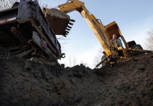
Bland said a snowless winter followed by a dry spring would create conditions at the start of next year’s growing season similar to the driest points of last summer’s drought. Then, he noted, powerful backhoes struggled to dig foundations or graves through rock-hard subsoil — the less fertile layer of earth anywhere from inches to feet under the topsoil.
“Imagine a seed trying to grow in that,” Bland said.
Water savings account 
Bland likened the subsoil to a water savings account that salvaged the 2012 growing season. Crops subsisted by tapping that moisture, giving most farmers at least something to harvest this fall. They also were helped by crops that are engineered to have deeper roots that can reach the subsoil.
But one of the driest summers since 1988 depleted that reserve.
“We went into the growing season this year with very favorable conditions, and we had that bank account to draw on. That subsoil moisture bank is what saved many, many fields across southern Wisconsin,” Bland said.
As it stands today, the drought is rated anywhere from abnormally dry to severe in the southern third of Wisconsin. “Multi-year droughts do happen,” said Bland.
Most recently, northern Wisconsin was gripped by drought from 2003 through 2010. The statewide drought in 1988 actually started in 1987 and lasted into 1989 for many parts of the state.
The good news is that Bland believes just an average amount of precipitation — depending on the location, 5 to 7 inches of rain or its equivalent in snow — is needed from now through next April in the southern third of the state to recharge the subsoil and ensure good growing conditions next spring.
The bad news is that climatologists aren’t confident that will happen because a weak El Nino system over the Pacific Ocean is making forecasting more difficult.
While most long-range forecasts are predicting a warmer-than-average winter, only half are predicting at least average precipitation or snowfall, according to professor Jonathan Martin, chairman of atmospheric and oceanic sciences at UW-Madison.
Snow is needed to add moisture as well as prevent it from evaporating from the ground, Martin said.
“If we have a winter like last year, when we had almost no snow cover in the southern part of the state, you can begin to lose more water somewhat invisibly,” he said. “Nobody really notices until the spring that the ground has really lost a lot of moisture over the winter. We need snow to prevent that from happening.”
Worse than 2012?
It’s hard for some to imagine drought conditions worse than what the southern third of the state experienced this year.
Crops began to suffer when some parts of the state got only about a half-inch of rain in June, which is on average the rainiest month of the year with over 4 inches in most places. The U.S. Drought Monitor labeled conditions “extreme,” the second-most-severe designation, in southern Wisconsin after below-average rainfall levels continued in July, August and September.
The drought’s effects were felt far and wide.
Corn plants produced little or no grain in places where there wasn’t enough rain to complete pollination. Some farmers cut their losses by chopping their corn early and using the stalks for feed. As grain prices rose, the drought also slowed hay production, putting added pressure on dairy and hog farmers to feed their animals.
There were reports that cows and hogs were being slaughtered across the country at the fastest rate in 25 years. Some large dairy farms, particularly those in California that are more dependent on buying feed, declared bankruptcy. And some ethanol plants slowed or shut down because they couldn’t afford corn — if they could find it.
Some grain farmers benefitted from those higher prices, offsetting corn yields that were nowhere close to the record levels of 2010 and 2011.
The bottom line for consumers was a higher price for dairy and meat products at the grocery store.
Drought continues
The drought is continuing in south central Wisconsin because moisture levels in the subsoil and aquifers are lagging behind despite good amounts of rainfall this fall. “We don’t have crops and landscapes growing, so it’s less terrifying to us right now,” said Bland.
But he didn’t mince words on what would happen if a dry spring and early summer follows a dry winter. “All of the crops will just crash and burn,” he said.
Based on current conditions and Wisconsin’s weather history, Bland believes south-central Wisconsin will get the needed precipitation to recharge the subsoil and groundwater reservoirs. “What would be best is lots of snow followed by a good, slow melt and no subsequent deep freeze,” he said.
Bland was also optimistic that sufficient surface moisture could get the growing season started next May even if the subsoil isn’t completely replenished. “And if rain keeps on track after that, we can have a respectable year,” he said.
Besides pleasing the farmers, that would also make workers at Roselawn Memorial Park in Monona very happy.
Dustin Kohn deals in subsoil every day as he digs graves at Roselawn. He said the ground became so hard last summer that the cemetery’s powerful backhoe needed an extra 15 minutes to dig out a standard grave.
“It got real hard-packed down there when the drought was at its worst. It got hard to chunk it all out of there,” Kohn said, noting that the subsoil is harder to handle than topsoil even when it’s moist.
Kohn said the whole process of laying out a grave, digging it to its standard depth of five feet (there’s no rule that graves must be six feet deep) and then trucking out the soil usually takes about 90 minutes.
“So if it takes 15 minutes longer to dig a grave,” Kohn said, “that adds up at the end of the day.”

Labels:

Friday, April 19, 2013

Indianford Dam Safety Checked by DNR today


Update – Rob was on site and noted the dam was submerged and has freeboard available to accommodate the additional 0.5FT increase predicted for the lake without overtopping the abutment.  There is currently 18 inches of freeboard available.

He has told Paul France(Regional WEM) and representatives of Rock County that he recommends not doing anything at this time and re-evaluate should the water levels rise above the predicted levels.

Thanks.

Bill

P William D. Sturtevant, P.E.
State Dam Safety Engineer
Dam Safety Floodplain Section
Bureau of Watershed Management
Wisconsin Department of Natural Resources
(() phone:     (608) 266-8033

Labels:

Indianford Dam being checked today


All,

Rob Davis, Dam Safety, is on his way to the Indianford Dam on Lake Koshkonong at the request of WEM. Rob will be making the decision related to a request to place fill on the right and left abutments of the dam to prevent the flow of water around the structure. Similar work was performed in 2008 when the lake reached record elevations.

Rob will be reviewing the request based on the physical situation at the dam and whether or not the work is actually necessary to protect the structure and the public. NWS has predicted a flood elevation on the lake at 12.5ft which is 2.6 feet lower than the elevation reached in 2008. The lake is currently at elevation 12.07ft.

Updates to follow.

Bill


P William D. Sturtevant, P.E.
State Dam Safety Engineer
Dam Safety Floodplain Section
Bureau of Watershed Management
Wisconsin Department of Natural Resources
(() phone:     (608) 266-8033

Labels:

Comparing Now to 2008


I’m probably not the first to make this comparison, but here is how this year’s rise compares to the big one in 2008
Ken

Labels: ,

Thursday, April 18, 2013

Hey Brian, What is a coffer dam?


This is an example of a coffer dam - what needs to be built in front of the powerhouse in Indianford to completely and effectively clean the trash racks and the organic material submerged.

If you know someone who can build these structures - later this fall when the lake level is low - have them call me.
608-884-9444


Labels: , ,

Improvements Needed at the Indianford Powerhouse

This is a mechanical trash rack cleaner, and soon after we build a coffer dam later this fall, we will have someone engineer and fabricate this tool.

The issue is, as noted earlier, too much sediment and sunken organic mass is clogging the trash racks from the bottom-up.

Also as noted earlier, the gates have NO IMPACT on high lake levels or the flooding that we are experiencing today.

The spillway elevation is far below where the river's elevation is at - so EVERYTHING is flowing over the spillway.


Labels: , ,

Blaming the Flooding on the Experimental Dredge Project?? REALLY??!!

Brian,

XXX was telling me about some idiot in the store explaining to anyone who would listen, that the high water on the Rock is because of the dredging.

"And they walk amongst us".  :)

XXX

Labels:

Dallman Landing on Charlie Bluff


Labels:

Sheriff’s office increasing patrols for Newville party


Sheriff’s office increasing patrols 

for Newville party


In an effort to deter drunken driving and underage drinking, the 

Rock County Sheriff's 

Office will be out in force at Newville’s Break in the Weather 

Party Saturday.

The office will assign extra deputies to patrol the annual
party on foot and 
with "saturation patrols," according to a news release.
Sheriff Rob Spoden said deputies will check bars for underage
 patrons, and will be out enforcing laws against drunken driving.

Labels:

1959 Flood


Brian:
Do you have an Indian Ford Pool reading for April 1959?
Tom
_________

Tom - 
I do not....I would have to research that for you.
Brian
_________________________

There are no official records for water levels on Lake Koshkonong prior to 1987, when the USGS gage was installed on Bingham point. So we have to take a look at discharge in the Rock River and the correlation between discharge in the river and the elevation of Lake Koshkonong to estimate the stage on Lake Koshkonong for April 1959.

To give you the bottom first, I estimate that the April 1959 flood had about 73% of the discharge of the 2008 flood, and probably reached a Lake Koshkonong stage of approximately 13.0 feet, gauge height, or 783.0 according to the "old" NGVD 1929 elevation datum.  As you know, the 2008 flood reached a gauge height of approximately 15.1 – meaning that the April 1959 flood was probably about 2 feet lower in height than the 2008 flood.

The Indianford dam gauge was installed in May 1975, so that won't help define how big the 1959 flood was. The USGS Watertown gauge was operating in the 1950s, but so far upstream that it might not be representative of the discharge that was going to Lake Koshkonong. However, the Rock River at Afton gauge between Janesville and Beloit has a more similar watershed area to Koshkonong and the Afton gauge has been in operation from 1914.

The peak daily discharge at Afton was 12,100 CFS on April 10, 1959.  The peak daily discharge for the 2008 flood at Afton was 16,500 CFS on June 22, 2008. The peak discharge at Indianford dam was 14,800 CFS, also on June 22. So the 1959 flood was large, but the 1959 flood discharge was only around 73% (12,100 / 16,500) of the 2008 flood discharge.

To estimate the Lake Koshkonong elevation for the April 1959 flood, we can make the assumption that the hydraulics of the Rock River have not changed much at high flood discharge (probably a good assumption) and the ratio of the 1959 to 2008 flood at Indianford was about the same as it was at Afton (probably a reasonably good assumption considering the size the watersheds). So our estimate of the 1959 flood at Indianford is 73% of the 2008 flood, or 10,800 CFS.  The stage on Lake Koshkonong that corresponds to 10,800 CFS is approximately 13.0 gauge height, based on the USGS discharge records at Indianford and the gauge records for the Lake. 13.0 gauge height corresponds to 783.0 using the "old" NGVD 1929 datum.

 
_________________


Labels: ,

Wednesday, April 17, 2013

Rock River continues to rise


Rock River continues to rise

Posted: Wednesday, April 17, 2013 11:34 am
With heavy rain in the forecast this week, water levels on an already-swollen Rock River and Lake Koshkonong were projected to continue surging higher.
The National Weather Service office in Sullivan has issued flood warnings along the Rock River at Jefferson, Fort Atkinson, Lake Koshkonong, Newville and Afton until further notice.
Water levels at Lake Koshkonong were at 11.62 feet as of 8 a.m. Wednesday morning and were projected to reach 11.8 feet after midnight on Thursday. Flood stage is 10 feet, and the National Weather Service considers water levels above 11.5 feet to be “major.”
If the forecast holds, water levels on the Rock River at Lake Koshkonong could be the third-highest on record, surpassing the 11.65-foot mark set on April 18, 2008. The two highest river crests were recorded at 12.23 feet on April 25, 1993, and 15.16 feet on June 22, 2008.
Water level forecasts take into account past precipitation and precipitation expected about 24 hours into the future from when the forecast is issued. The weather bureau is predicting 2-3.5 inches of rain will fall on South Central Wisconsin between Wednesday and Thursday due to a strong and slow-moving low pressure system.
In Newville, river levels were at 7.79 feet, surpassing the major flood stage mark of 7.5 feet. Flooding begins to occur at 5.5 feet. It was unknown how high the water could get in Newville because flooding forecasts are not issued for that location.
River levels can be monitored online at water.weather.gov.
The Rock County Sheriff’s Office on Monday said it was monitoring the flooding in several locations. In Mallwood Estates, Lake Shore Drive is closed from East Road 3 to East Road 7, and East Road 9 is closed from Ridge Road to the road’s end to the east.
Citizens in need of sandbags are encouraged to contact their respective town chairperson for pick up, the sheriff’s office said. Sand will be available for Town of Fulton and Town of Milton residents at the Rock County Highway Department sheds located at Highway 59 and North Sherman Road in Edgerton.
Residents are reminded to avoid traveling across high waters on roadways and report any hazardous conditions related to the flooding to Rock County Communications at 757-2244.

Labels: