Binghams Point Public Access Association
Brian, can the lake district tell us if this is legal?
RM
RM -Wednesday, January 26, 2011
This is the first I have heard about it...let me check into it.
Brian
Koshkonong access cleanup this Saturday
By Randall Dullum
Union news editor
KOSHKONONG - Ice fishermen and other interested persons are being encouraged to help clean and mark the White Crow Pass public right-of-way to accommodate access to Lake Koshkonong this Saturday, Jan. 29.
The clean-up day at Oxbow Bend-Bingham's Point will begin at 8 a.m., with work is expected to be completed by the afternoon. Shovels, rakes, snowplows, backhoes, dump trucks, etc., will be used to perform the work.
"Bingham's Point is one of the jewels of Lake Koshkonong - it's a great fishing spot," commented John Rinehart, chairman of a group calling itself the Binghams Point Public Access Association. "For 60 years, this access has been kept a secret from ice fishermen.
"Recently discovered courthouse records show a public access called 'White Crow Pass,'" he added. "This is probably one of the biggest surprises to hit the lake in the last 30 years."
The Milton resident said he went to the Rock County Courthouse three months ago and began checking plat maps to see if there was an access to the lake in that location.
"We're talking the east side of the lake, between the other access points of Vinnie Ha Ha and Charlie's Bluff," Reinhart said. "We've got a whole section in the middle that you can't access.
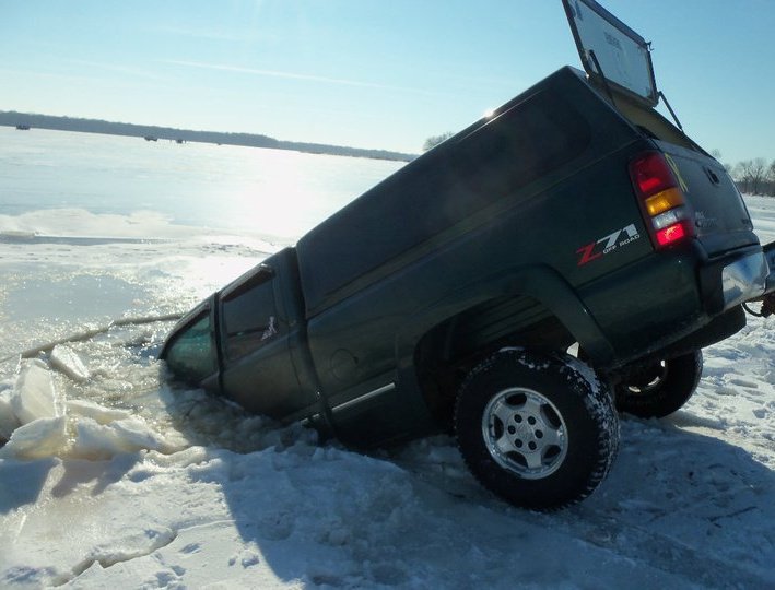
"There's a danger right now of (ice fishermen) crossing the lake to get to Bingham's Point," he added. "There are cracks in the ice, pressure ridges, and already seven cars have fallen through the ice yet this year."
Once improved, Rinehart said, this new Bingham's Point access - which will be 50 feet wide and offer new, level drive-on access - will allow fishermen to travel out onto the ice with minimum danger.
The access point is located within a subdivision off of Oxbow Bend. Whenever a subdivision is built, he said, Wisconsin statutes require that there must be at least 60 feet of access from the water to a public roadway.
On Jan. 12, the Town of Koshkonong Board of Supervisors approved Rinehart's request to clean up and mark with signage the White Crow Pass public right-of-way on Oxbow Bend as an access point for ice fishermen on Lake Koshkonong.
Supervisors reviewed the current concerns about Bingham's Point and what could be done to avoid further dangers on the lake near the site.
Rinehart said he has inspected the area and found only two trees that would need to be removed Saturday to improve the area for access. Also, signage will be erected declaring the area as a town right-of-way offering public access to the lake.
"We need the public's help this Saturday to clean it up," Reinhart said. "So fishermen are encouraged to turn out. It's an historic chance to be involved in something for Lake Koshkonong.
"It's going to be a very nice place for the public to enjoy," he remarked. "We're very excited."
To find the new access point from State Highway 26, persons traveling south should turn right onto County Highway N in Rock County, then proceed one-half mile and turn right onto Vogel Road. They should continue straight to Bingham's Point and take the first left turn on the point. After crossing the canal at the bridge, persons should turn left onto Oxbow Bend.
Labels: County - Local Regulation
posted by Slide @ 9:37 PM
![]()